
Trial hole excavation, measuring elevation, cellar conditions, movement monitoring and more
SPECIALIST SURVEYS
Accurate, Reliable, and Cost-Effective Surveying Services
As a surveying company, we have the capability to successfully complete your unique survey assignments, including trial hole excavation reports, cellar condition surveys, network transformations, movement monitoring, volumetric surveys, elevation surveys, and other bespoke surveys . Our rigorous quality control process ensures that your project is completed to the highest standards, and we are always available to answer your questions and provide the information you need to make informed decisions about your project. Please explore our services and contact us today to discuss your project requirements.
Get in touch →

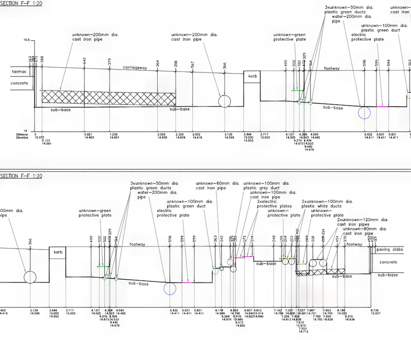
A trial hole in highway construction refers to a small excavation or test pit dug at a specific location within a project area. The trial hole allows engineers and construction teams to assess the suitability of the site for the planned highway project, determine the stability of the soil, identify potential hazards or obstacles, and make informed decisions regarding the design and construction methods to be employed. The information obtained from trial holes helps ensure that the highway is built on a stable and safe foundation.
Due to the limited duration of these excavations, our team must diligently and professionally gather all relevant information, as there is no chance for a second take. Subsequently, the collected data are processed at our office, and a georeferenced 3D CAD drawing is generated, accompanied by a sufficient number of cross-sections to accurately depict the site conditions. Additionally, the drawings are enriched with on-site photographs for comprehensive documentation.
TopoCrew has successfully completed more than 1,000 trial hole excavation reports to date, showcasing the high standard of our work. This substantial figure is a testament to the quality we consistently deliver.
Trial Hole Excavation Reports

In London, it is not uncommon for the basement of a building to extend beneath the public highway. Prior to commencing a highway construction project in such areas, it holds significant importance to document the existing conditions of these basements. This ensures that a "before" snapshot in time is captured, in case any damage claims arise from the property owners. This proactive approach helps establish a comprehensive record and assists in resolving potential disputes related to the construction activities impacting these cellar structures.
To date, TopoCrew has conducted surveys of nearly 300 cellars. Effective communication and swift execution are key factors, as they play a critical role in minimising disruptions to businesses.
Cellar Condition Surveys
“TopoCrew carried out the necessary site checks in order to meet the City specification and requirements, and were able to stich the surveys and deliver one 3d model to enable the design to progress. This approach was beneficial in delivering the project with savings both in monetary terms and time.”
Ben Manku
Construction Manager
City of London Corporation
Neighbouring projects frequently work in different coordinate systems, and these situations often result in problematic scenarios when the two projects intersect. Level values may appear identical on drawings, but they are referenced to different benchmarks and as a result in reality levels are different. This mismatch can lead to complications:
-
Misalignment between steps built during a public highway project and thresholds built by the property developers.
-
Seemingly straight lines depicted on plans can exhibit unexpected deviations or "dog leg" kinks at the joint where the projects meet.
To avoid these issues, it is crucial to establish consistency across relevant projects by implementing a shared grid and utilising common reference points. To achieve this, we will conduct a comprehensive site survey and collaborate with all stakeholders to determine the preferred reference system. Subsequently, we precisely transform all drawings and data into this unified system, providing you with a peace of mind, knowing that potential conflicts from disparate survey grids will be effectively eliminated.
Network Transformations

Movement monitoring is vital for ensuring the safety and integrity of structures, identifying potential risks and hazards, optimising maintenance and asset management, and accounting for environmental factors. By continuously monitoring movement, engineers can detect any changes or abnormalities in a timely manner and take appropriate actions to mitigate risks. This proactive approach helps prevent accidents, ensure the longevity of structures, and protect lives and properties. Additionally, movement monitoring aids in optimising resources and decision-making for effective maintenance and management of infrastructure.
Our diligent monitoring team consistently prioritises the accuracy, reliability, and comparability of data collected during survey series conducted at regular intervals. Given that some monitoring projects span multiple years, it is crucial to maintain a reference point network to ensure consistent and reliable measurements over time.
Monitoring

For various applications such as road planning, surfacing, salt depots, stockpiles, or open-pit mines, TopoCrew offers a range of surveying solutions utilising a state-of-the-art fleet of total stations, laser scanners, and drones. Leveraging the survey data collected, TopoCrew can generate and analyse digital 3D models, conduct surface comparisons, and calculate cut and fill volumes.
This enables efficient and accurate assessment of surface conditions, facilitating informed decision-making and precise planning for your construction or logistical projects.
Volumetric Surveys and Calculations

Elevation surveys are essential for architects and structural engineers. They offer vital details about a building's facade, window arrangements, floor level separation, staircases, services, and more by measuring the vertical arrangement of a building or structure. Elevation drawings can be either external, detailing the outside of a building, or internal, showing a section through the structure.
TopoCrew's specialised and highly experienced team conducts elevation surveys using modern laser scanners, total stations, and drones. We achieve exceptional accuracy and efficiency, ensuring the most reliable and precise results even in challenging or inaccessible terrain. Rigorous quality control throughout the entire survey process ensures the data collected is reliable, consistent, and meets the highest standards.
Local authorities, commercial, and private clients rely on us for dependable and accurate elevation surveys. We are known for our attention to detail, professionalism, and commitment to meeting client requirements.
Elevation Surveys


